

HIKES & EVENTS
Mount Israel Loop Hike
Full Day Hike
DATE: Aug 07, 2021
END DATE: Aug 07, 2021
Hike/Event Location: Sandwich NH
Trip Leader(s)
tdefauw
Plymouth, NH United States,
jkelaghan
Plymouth, NH United States
Meeting Time: 10:00 AM
Max # People: 12
Hike Guiding / Event Fee: No, I will not be asking participants for money
Hike Difficulty Level:
Moderate
(Do you qualify to attend with this hike difficulty rating? Click Here.)
Sign Up To This Trip/Event
You must be a least a guest member to participate. Comments such as "+1" or "bringing a friend" are NOT permitted. All participants must sign-up for the event individually.
Select your mode of transportation, make any comments and then click on button.
You are not logged in.
Please, Log In
Summary
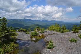
Join us for this moderate loop hike that begins with the Bearcamp Trail on Sandwich Notch Road. This moderately flat trail of 0.6 mi includes time along the Bearcamp River and a stop at Beede Falls and a view of Cow Cave. At 0.6 mi we join the Wentworth Trail and hike for 2.1 mi through beautiful forest to the peak of Mt Israel.If the clouds cooperate, we should see great views of the Lakes Region along the way and from the peak. From the summit we will descend 1.7 miles on the Mead Trail and then 1.7 miles Guinea Pond Trails, followed by a walk of about 2 miles on Sandwich Notch Road. The loop hike is about 8.2 miles and 1850 feet of elevation gain.
We'll eat lunch at the peak, so bring your lunch. Also bring or wear layers to accommodate late August temperatures. It's always important to bring at least 1 liter of water, rain gear, sunscreen, and bug spray.
Rain will cancel.
Directions To Trailhead Parking Lot

You can put "Beede Falls" into your GPS, but note that some GPS devices will direct you to go to far along Sandwich Notch Rd. The trailhead is in Sandwich Notch Park on Sandwich Notch Rd, 3.2 miles from Center Sandwich. From intersection of Rt 113 and Grove St, head northwest on Grove St and travel 2.5 miles (road changes name to Diamond Ledge Rd at some point and also becomes gravel road after 1.5 mi). The road then forks, and sign directs you to bear left for Sandwich Notch Rd. Go 0.7 miles. Trailhead parking lot is on right and labeled “Beede Falls.” Please give yourself a little extra time to accommodate travel on gravel roads.
Trip Leader(s)

 Invite To Be Your Buddy
 Send Email
- Online Status: OFFLINE
- Last Login: 05/05/2024 05:41 AM
- Member Since: 10/30/2001
- Approved By: tdefauw
- Online Status: OFFLINE
- Last Login: 05/01/2024 09:32 AM
- Member Since: 10/02/2002
- Approved By: tdefauw
members signed up for this event

- Online Status: OFFLINE
- Last Login: 10/27/2022 03:48 PM
- Member Since: 10/30/2001
- Driving My Own Car
(Willing to give guys a ride)
- Online Status: OFFLINE
- Last Login: 10/22/2022 07:24 AM
- Member Since: 02/04/2018
- Driving My Own Car
(Possibly willing to give guys a ride)
 |
 |
