Trip report
Mount Crawford Hike
Hiking/Walk DATE: 09/14/2013 - 09/14/2013
Trip/Event Location: Harts Location (Bartlett), NH
US
Trip Leader(s):
Max # People: 12
Trip Guiding / Event Fee: No, I will not be asking participants for money
Difficulty Level: Moderate
If you’re looking for a fun hike that offers a big mountain feel for a modest effort, this is your opportunity brotha! An ‘up and back’ trek with an elevation gain of 2100’, the 3,119-foot summit of ...
Driving directions to the location and spot to meet at:
From the east take NH Rt 16N to Rt 302W and drive approx 12.7 miles. The Davis Path parking lot will be on your right. From the south or west, take I93N to exit 35 onto US Rt 3N toward Twin Mountain. Drive 10.3 miles to Rt 302E, then drive approx 16.4 miles. The Davis Path parking lot will be on your left.
Trip Report/Photos
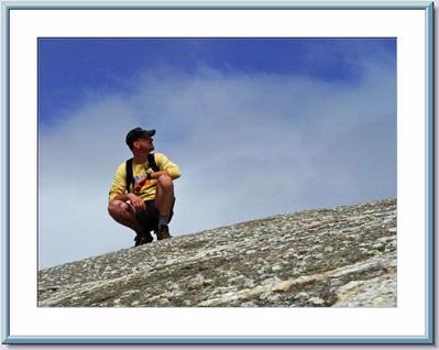
 On a cool and rainy Saturday morning, 8 enthusiastic hikers met at the Davis Path trailhead parking area at 9:15am on September 14, 2013 to ascend the picturesque summit of Mt Crawford.
With unexpected overnight and early morning showers a few members had decided to cancel and others unsure, but Scott and I were determined that the weather would break favorably and our instincts were right. We got there early, around 8:30am, with only Tim’s car in the entire parking lot and a confused looking Burmese Mountain dog near the Saco river that Scott coached back to the Inn across the street.
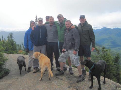
By 9:30, after introductions were made... Tim, Tom, Tyler, George1, George2, Bob, Scott & I, along with our canine companions Sonny, Comet & Halley, headed out over the Bemis suspension footbridge, across the Saco river and entered the into the woods of the WMNF.
An easy, gentle grade along an old logging road that follows a wide but shallow brook, we soon crossed into the Presidential Range-Dry River Wilderness. At 0.9 miles, we took a sharp right to enter the old bridle path, ascending the moderately steep ridge between Mt Crawford & Mt Hope through a series of switchbacks & zig-zags. The temperatures now pushing over the 60 degree mark with increasingly clearing skies, we stopped at various points to shed layers, hydrate and catch our breath.. all the while maintaining a fairly relaxed but steady cadence.
Following the ridge north, we reached the crest at 1.9 miles to discover remarkable views on a damp ledge lookout with fairly clear sightings of Carrigain & Tripyramid. With some patches of blue skies, the distant visibility was still heavily filtered, so after a quick snack we decided to press on.
At 2.2 miles, we reached the side trail that diverges left up the still damp sloping ledge leading to the open, bare peaked summit of Mt Crawford. After some brief deliberation to check out Mt Resolution first we headed left and with mildly scattered effort levels amongst the group, we were reunited at the summit just before 11:00am. Fairly windy and cool temps in the 40’s, we decided to hang out and soak in the panoramic views of Crawford Notch and the Dry River Valley. The Presidential Range was nearly invisible as higher elevations were cloud covered, including the nearby top tier of Stairs Mountain.
After a relaxing lunch, some good conversation and a round of identifying the nearby peaks, we decided to strap on our packs and descend back down the trail.
Following an effortless and gravity fed decent, the group reached the Bemis bridge at around 1:30pm. We all hung out and chatted for a bit, then most of the group headed up to Fabyan’s in Bretton Woods for a bite to eat before heading out on our separate ways.
Thanks guys for joining us on one of my all time favorite ½ day hikes. Big thanks to Tim for taking and posting the photos and congratulations to Scott for wrapping his maiden GO voyage and debut Co-lead all in one. See you boys next time… Peace, Kevin
On a cool and rainy Saturday morning, 8 enthusiastic hikers met at the Davis Path trailhead parking area at 9:15am on September 14, 2013 to ascend the picturesque summit of Mt Crawford.
With unexpected overnight and early morning showers a few members had decided to cancel and others unsure, but Scott and I were determined that the weather would break favorably and our instincts were right. We got there early, around 8:30am, with only Tim’s car in the entire parking lot and a confused looking Burmese Mountain dog near the Saco river that Scott coached back to the Inn across the street.
By 9:30, after introductions were made... Tim, Tom, Tyler, George1, George2, Bob, Scott & I, along with our canine companions Sonny, Comet & Halley, headed out over the Bemis suspension footbridge, across the Saco river and entered the into the woods of the WMNF.
An easy, gentle grade along an old logging road that follows a wide but shallow brook, we soon crossed into the Presidential Range-Dry River Wilderness. At 0.9 miles, we took a sharp right to enter the old bridle path, ascending the moderately steep ridge between Mt Crawford & Mt Hope through a series of switchbacks & zig-zags. The temperatures now pushing over the 60 degree mark with increasingly clearing skies, we stopped at various points to shed layers, hydrate and catch our breath.. all the while maintaining a fairly relaxed but steady cadence.
Following the ridge north, we reached the crest at 1.9 miles to discover remarkable views on a damp ledge lookout with fairly clear sightings of Carrigain & Tripyramid. With some patches of blue skies, the distant visibility was still heavily filtered, so after a quick snack we decided to press on.
At 2.2 miles, we reached the side trail that diverges left up the still damp sloping ledge leading to the open, bare peaked summit of Mt Crawford. After some brief deliberation to check out Mt Resolution first we headed left and with mildly scattered effort levels amongst the group, we were reunited at the summit just before 11:00am. Fairly windy and cool temps in the 40’s, we decided to hang out and soak in the panoramic views of Crawford Notch and the Dry River Valley. The Presidential Range was nearly invisible as higher elevations were cloud covered, including the nearby top tier of Stairs Mountain.
After a relaxing lunch, some good conversation and a round of identifying the nearby peaks, we decided to strap on our packs and descend back down the trail.
Following an effortless and gravity fed decent, the group reached the Bemis bridge at around 1:30pm. We all hung out and chatted for a bit, then most of the group headed up to Fabyan’s in Bretton Woods for a bite to eat before heading out on our separate ways.
Thanks guys for joining us on one of my all time favorite ½ day hikes. Big thanks to Tim for taking and posting the photos and congratulations to Scott for wrapping his maiden GO voyage and debut Co-lead all in one. See you boys next time… Peace, Kevin
- The Trip Has No Photos -
|
|
||