Trip report

Great Ossipee (Mt Shaw) Hike

Hiking/Walk DATE: 04/30/2011 - 04/30/2011

Trip/Event Location: Tuftonboro, NH
US

Trip Leader(s): jonathanclark

Max # People: 12

Trip Guiding / Event Fee: No, I will not be asking participants for money

Difficulty Level: Moderate to Strenuous

Please join me for my favorite early spring hike to the summits of Black Snout (2803') and Mt Shaw (2990'), highest "peaks" in the Ossipee Mountains.  The overall moderate roundtrip is

...
Driving directions to the location and spot to meet at:


 The Shaw Trailhead is located in Tuftonboro, New Hampshire.

From Rt. 16:

  • From Rt. 16 in Ossipee, take Rt. 171 west (Old Granite Road which turns into Mountain Road after crossing route 28).
  • The trailhead is 9.7 miles west of the junction of routes 171 and 28.
  • There's a small parking area on the right (north) side of the road, just before a bridge over Fields Brook; on the other side of the bridge on the left side of the road is Sodom Road which you can use as a "you've just missed the trailhead" marker.
  • There are no trailhead signs.

From I-93:
  • Take exit 23 off of I-93 and follow Rt. 104 east for about 8 miles until it ends in Meredith.
  • Turn left onto Rt. 3 and go about 0.8 mile to a traffic light just beyond the public docks.
  • Turn right onto Rt. 25 and travel 10.1 miles passing through Moltonborough village.
  • Turn right onto Rt. 109 and go 2.2 miles.
  • Turn left onto Rt. 171 east and follow it for 3.9 miles.
  • You will pass Sodom Road on the right, immediately cross a bridge over Fields Brook, then you should immediately turn left into the small trailhead parking area.
  • There are no trailhead signs.


Trip Report/Photos
Featured Photo

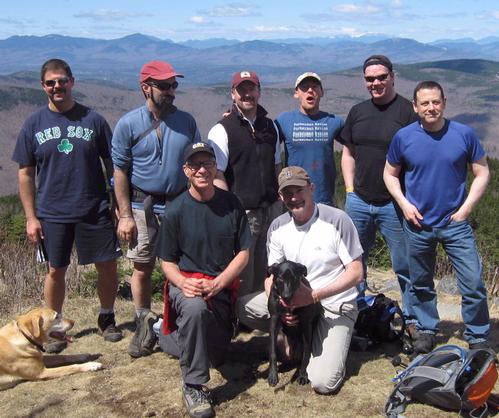
8 GO members and 3 dogs summited the imposing peaks of Black Snout and Great Ossipee on a nearly perfect spring day.  Men and beasts all seemed to get along well and enjoy the hike and clear views of lakes and mountains.

- The Trip Has No Photos -

Members That Participated

jonathanclark

Outdoor Fitness Level: Moderate


Hartford, CT


United States
fanoftrees

Outdoor Fitness Level: Moderate to Strenuous


Candia, NH


United States
jpkant

Outdoor Fitness Level: Moderate


Northwood, NH


United States
markmtn

Outdoor Fitness Level: Strenuous


Asheville, NC


United States
<
Hiking, backpacking, camping or vacation adventures, GayOutdoors [GO] has been the LGBTQ outdoorzy community leader for the last 22 years. We are an informal group of diverse hiking enthusiasts in the United States with a shared love of the mountains who prefer hiking with friends. We invite you to join us on our hikes, to post hikes for other members to join you and to share your hiking photos, stories and advice.

Become A Member

If you find it invigorating to hike along a mountain trail with friends not knowing what’s just around the corner, to get some fresh air, to stop and soak in the views on a summit, and to soak your feet in a mountain brook after a hike, give us a try!

BECOME A MEMBER


Powered by Ecomsolutions.net - ColdFusion Experts