
learn
Beginner Snowshoeing Workshop On Ice
By Mike Boisvert.
This was advertised as a beginner snowshoeing workshop, but some ice walking was thrown in due to recent weather. Due to the lack of snow around the Waterville Valley area we traveled an hour north to Crawford Notch, NH. Besides the instructors, Jon N. and myself, we had the following intrepid snowshoers: Richard C., Steve B., and Dave M.
Our first snowshoe hike for the weekend was up to Mt. Avalon.
MT. AVALON
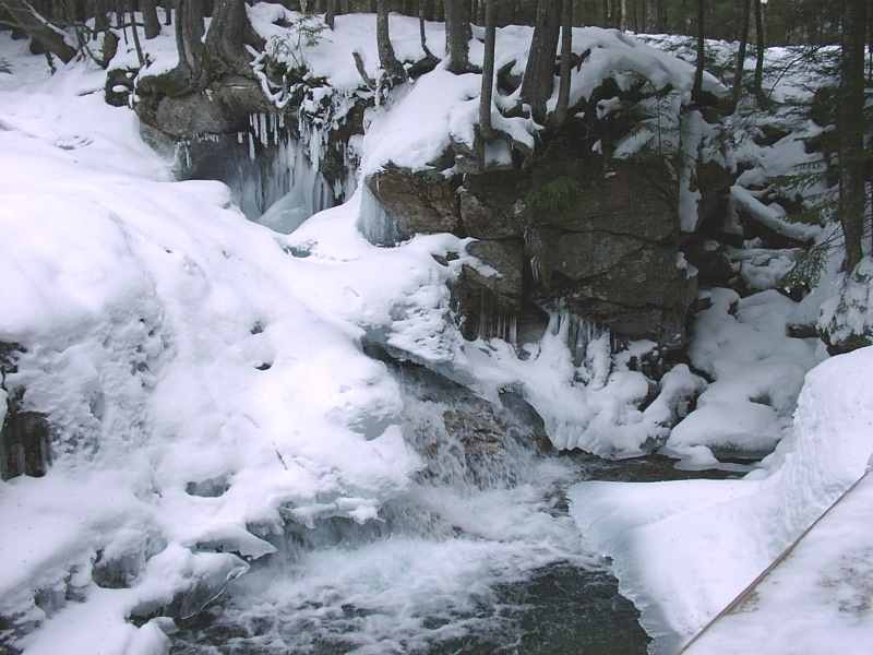
The terrain is built for beginners. The Avalon Trail begins across the Conway Scenic Railroad tracks south of the depot. The path was wide at first. Scenery was graciously provided by a brook to our left and occasional views of mountains rising out. The temps were mild, the snow crisp and spirits were high. There is something about walking with friends, old and new, in the great outdoors that makes one feel alive. Cares melt away, at least for a few hours. I always feel tired, but vitally refreshed after hiking.
We shortly came to the valley’s brook. The water was high due to all of the recent rain. This made the crossing using snowshoes challenging for first timers. We had another crossing soon after this one and thankfully not as challenging.
From here we began the climb. At the junction of the A-Z Trail we took a left and the trail became much steeper. The steep pitches had icy patches. We taught everyone to trust the built-in crampons underneath the snowshoes and walk straight up the ice. As we continued toward the summit we noticed a Gray Jay was flying beside us and perching near a branch whenever we stopped. He followed us all the way to the summit and we rewarded him with some food in our packs.
When we reached the summit of Mt. Avalon the wind had picked up and it began to snow. Even with limited visibility we had a view of the highway winding through Crawford Notch and Webster Cliff’s stark mass of sheer rock buttressing northward. On our return, we demonstrated the proper way to fall on your butt and slide down the steep sections. The tail end of the trip was remarkable. We found ourselves in the middle of a thunder and lightning storm; except that we were being pounded by sleet, ice pellets and snow.
SCAUR HIKE
The day after the beginner hike, we did it again. This time Rich C. and Steve B. joined us. We decided to stay closer to the Mad River Lodge so we decided to tackle the Scaur in Waterville Valley. Unfortunately this meant that snowshoes were not needed due to lack of snow cover.
The Livermore Road that we hiked on resembled more like a frozen canal that one would expect to see ice skaters on. We had to walk very carefully and made note of the bridge  over the Mad River. An hour later we reached the Kettles Trail and started towards the base of the Scaur.
We entered a magnificent forest of spruce and hardwoods. We traversed besides the Kettles, which are bowl shaped depressions carved by glaciers 10,000 years ago. We suspect the tracks we saw in the snow was from a raccoon.
The climbing became much steeper after the junction of the Scaur spur trail. This trail was real icy. Jon decided to try on the Stabilicers I bought him for Christmas and he said they worked great.
On the real steep pitches we went off-trail and grabbed hold of trees; except for Jon. At this point our beginner snowshoers were wondering if they had signed up for an ice-climbing workshop by mistake.
We soon reached the top of the Scaur. The Scaur is a rock ledge overlooking Waterville Valley. It was a beautiful sunny day. Our attention was directed to the Waterville Valley Ski Area. The snow conditions were so poor that the we saw few skiers and riders on the trails.
We heard a helicopter which is very unusual in this area. We suspect that perhaps a skier had experienced a fatal fall on the icy ski slopes. Leaving the top of the Scaur Ledge, we basically slid down on our butts on the steep sections.
To make this a loop trip we continued on the Scaur trail to Greeley Ponds and encountered two similar steep sections that we had to slide down. When we reached the Mad River, we discovered it could not be crossed due to high water. Jon and I were not about to cross barefoot in icy water. We did that on another hike in Waterville Valley a few weeks ago that we cared not to repeat.
So we decided to bushwhack and follow the river so we could use the Mad River bridge that we had seen earlier on Livermore Road. At this point our beginner snowshoers were wondering if they should have signed for this workshop at all!
The bushwhacking was easy and a good experience. We soon reached the Livermore Road and crossed the Mad River using the bridge.
The best part of the weekend was that our beginner snowshoers said they loved it and will be doing again! With the conditions we had this weekend, we trained them for all kinds of winter conditions.
© 2006 Gay Outdoors ; All Rights Reserved.
