

HIKES & EVENTS
Black Mountain Hike
Hiking/Walk
DATE: Feb 22, 2020
END DATE: Feb 22, 2020
Hike/Event Location: Benton NH
Trip Leader(s)
Gandalf
Thornton, NH United States,
JDNnh
Thornton, NH United States
Meeting Time: 10:00 AM
Max # People: 15
Hike Guiding / Event Fee: No, I will not be asking participants for money
Hike Difficulty Level:
Moderate
(Do you qualify to attend with this hike difficulty rating? Click Here.)
Sign Up To This Trip/Event
You must be a least a guest member to participate. Comments such as "+1" or "bringing a friend" are NOT permitted. All participants must sign-up for the event individually.
Select your mode of transportation, make any comments and then click on button.
You are not logged in.
Please, Log In
Summary
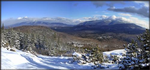
The finest summit in the little Benton Range west of Mt. Moosilauke at 1,800 feet, offers an expanse of open ledge at the top! There are wide views of the Connecticut River valley to Vermont, south to Black’s Benton Range neighbors the Middle Connecticut River Mountains, and east to Moosilauke, the Kinsmans and more. The upper section of the Chippewa is STEEP. We’ll have an opportunity for a fascinating detour to the Lime Kilns, huge ovens used in the 1800s to release lime from limestone.
The trail starts directly upward among dense pines and then among juniper through more overgrown fields. On the summit, we’ll search for Tipping Rock, a huge glacial erratic. As you can see, the views are terrific! Bring lunch, water and dress in layers.
Trail Specifics:
• Roundtrip Length – 3.75 Miles
• Elevation Gain - 1800 Feet
• Expected Time - 3.5 to 4 hours
What to wear/bring: MicroSpikes and Snowshoes. Have your snowshoes strapped to your pack at first because we might not need them at the start. Wear warm clothing suitable for the exposed ledge and summit(s)...no cotton or blue jeans. You should also have insulated boots suitable for the season. Additionally, consider bringing neck gaiter/scarf, face protection and a headlamp/flashlight. Bring along at least 1 liter of water, lunch, snacks and anything else you may require for a day hike.
If you have any questions, please reach out to us in advance.
Après Hiking Dinner Saturday: Everyone is welcome to join us back at our house in Waterville Valley to relax beside our fireplace views of the Sandwich Mountain/Mad River [BYOB and bring snacks] followed by one of Jon's delicious dinners. We ask $10 per person to help pay for our food costs. Showers are available so bring a change of clothing to make your visit with us more comfortable.
Lodging Option: Bunk beds are available at our house [with Wi Fi] near Waterville Valley, NH for Friday and/or Saturday night. It's $25 for each night that includes dinner. Coffee/bagels each morning and linen/blankets/towels are provided. Space is limited so email ASAP to reserve a bunk!
Directions To Trailhead Parking Lot

Chippewa Trail parking via Rt 116;
Route 93 north to Exit 32, right at bottom of exit ramp
Route 112 west towards Woodstock (and Woodsville & "Lost River") (for about 12.5 miles)
(Stay on 112 past the junctions for 118 and 116 North)
Route 116 SOUTH towards Benton (for 7.5 miles)
(Stay on 116 through Benton)
Left on to Lyme Kiln Road (for about 1.8 miles)
(Lime Kiln Road is about half mile past Windy Ridge Orchards on 116)
We'll be driving a blue Tacoma truck.
Trip Leader(s)

 Invite To Be Your Buddy
 Send Email
- Online Status: OFFLINE
- Last Login: 04/17/2024 02:46 PM
- Member Since: 08/20/2001
- Approved By: Gandalf
- Online Status: OFFLINE
- Last Login: 04/16/2024 08:45 AM
- Member Since: 10/30/2001
- Approved By: Gandalf
members signed up for this event

- Online Status: OFFLINE
- Last Login: 04/17/2024 08:57 AM
- Member Since: 02/23/2003
- Driving My Own Car
(Possibly willing to give guys a ride)

Hey boys where the weather looks good, I decided to come up for the hike. I will plan on staying over Saturday night. Should be fun. It has been a while. Can I meet you at PO per usual lol?
 |
 |
