

HIKES & EVENTS
Jennings Peak Hike
Hiking/Walk
DATE: Aug 24, 2019
END DATE: Aug 24, 2019
Hike/Event Location: Waterville Valley NH
Trip Leader(s)
JPHiker
Lake Worth Beach, FL United States
Meeting Time: 10:00 AM
Max # People: 8
Hike Guiding / Event Fee: No, I will not be asking participants for money
Hike Difficulty Level:
Moderate to Strenuous
(Do you qualify to attend with this hike difficulty rating? Click Here.)
Sign Up To This Trip/Event
You must be a least a guest member to participate. Comments such as "+1" or "bringing a friend" are NOT permitted. All participants must sign-up for the event individually.
Select your mode of transportation, make any comments and then click on button.
You are not logged in.
Please, Log In
Summary
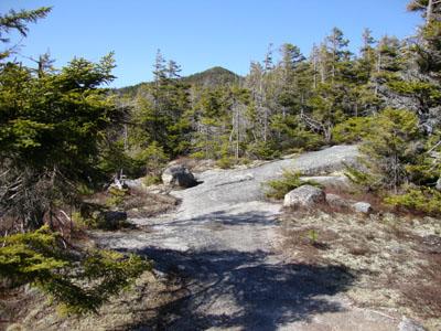
The ledges of Jennings Peak (3,440 feet) offer some nice views of the Welch-Dickey range across the way, and of the peaks around Waterville Valley. We will be going up via the Drakes Brook trail, which is a fairly moderate trail. There are a couple of steep sections, however, which will test your stamina, but thankfully are relatively short...and sweet. The trailhead is at 1,400 feet altitude, and from there to the top of Jennings Peak is 3.5 miles. We plan to return via the same trail, for a round trip total of 7.0 mile. Note that from the parking lot, this will involve a 2,040 foot ascent (and descent). So, even though this is generally considered to be a moderate hike, it does involve quite a bit of climbing. Please bring at least two liters of water, snacks, and lunch for the top. Also bring good sturdy hiking shoes, and appropriate gear. If there is desire to do so, we can opt to return to the trailhead via the Sandwich Mtn.Trail, which is a bit longer and requires a stream crossing, but ends up at the same parking lot as the Drakes Brook trailhead.
Rain or at least a 50% chance of such an event, will cancel. I will keep people posted Thursday evening and/or Friday regarding conditions.
Directions To Trailhead Parking Lot

We will meet at the Drakes Brook & Sandwich Mtn. Trailheads. To get there, get off Exit 28 on I-93 (Campton/Waterville Valley) and go east on Route 49 (Mad River road) for about 10 miles, or to .4 miles before the junction of route 49 with Tripoli Road and the Waterville Valley town limit. Be on the lookout for a small trailhead hiking sign on the ride side of the road. It is easy to miss, so if you get to the sign for Tripoli Road, and Waterville Valley, you went too far. The trailhead parking area is fairly small and this being a Saturday it may be full. In that case, park on the side of the road. Depending on how many people, and cars are coming, we can arrange to meet at the Campton Post Office parking area, just off exit 28, and carpool from there.
Trip Leader

 Invite To Be Your Buddy
 Send Email
- Online Status: OFFLINE
- Last Login: 04/15/2024 07:05 PM
- Member Since: 11/11/2002
- Approved By: JPHiker
members signed up for this event

- Online Status: OFFLINE
- Last Login: 04/17/2024 08:57 AM
- Member Since: 02/23/2003
- Driving My Own Car
(Possibly willing to give guys a ride)
 |
 |
