

HIKES & EVENTS
CANCELLED — Evans Notch - Deer Hill
Hiking/Walk
DATE: Jul 15, 2018
END DATE: Jul 15, 2018
Hike/Event Location: Stow ME
Trip Leader(s)
MO
Lancaster, NH United States
Meeting Time: 10:00 AM
Max # People: 12
Hike Guiding / Event Fee: No, I will not be asking participants for money
Hike Difficulty Level:
Easy to Moderate
(Do you qualify to attend with this hike difficulty rating? Click Here.)
Sign Up To This Trip/Event
You must be a least a guest member to participate. Comments such as "+1" or "bringing a friend" are NOT permitted. All participants must sign-up for the event individually.
Select your mode of transportation, make any comments and then click on button.
You are not logged in.
Please, Log In
Summary
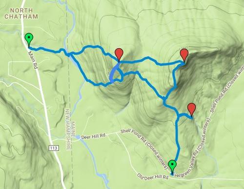
In Evans Notch we will climb Little & Big Deer Hills and visit the Deer Hill Springs along the way.
From the trailhead on Shell Pond Road/Evergreen Valley Road we will hike to Deer Hill Springs. From there we will take the southern branch of the trail to the Cold River. We’ll take a right and climb to Little Deer Hill. From there we will continue to Big Deer Hill. Lunch Time! After lunch we will then head south back to the trailhead. For those who would like to extend the hike (once back to the parking area) we can hike either Lord Hill or Pine Hill. We’ll discuss options once back at the parking area.
Estimated Elevation Gain: a bit over 1000 feet
Estimated Distance: 5 miles
Estimated Duration: 3.5 hours
Link to hike information and map (note: we will hike from the trailhead off Shell Pond Road/Evergreen Valley Road (NOT the Baldface parking lot on route 113):
https://mainebyfoot.com/little-and-big-deer-hills-white-mountain-national-forest/
Hiking Essentials:
A backpack
Lunch & snacks
Water & more water (at least 2 liters)
Hiking footwear with fairly stiff soles and good traction
Dress in layers (note: will cancel if rainy)
Sunglasses
Sun Screen
Bug/Tick Repellent
First aid kit -- assemble one with what you have at home (bandages, gauze, tape, sanitizing gel, etc)
See recommendations from GayOutdoors:
https://www.gayoutdoors.org/page.cfm?typeofsite=storydetail&id=992&storyset=yes
Directions To Trailhead Parking Lot
Follow Route 113 either approximately 17 miles north from Fryeburg (or, if coming from the north, approximately 13 miles south from Gilead). Take Deer Hill Road (off of Route 113, south of the Baldface Circle parking lot). When Deer Hill Road splits stay to the left onto Shell Pond Road/Evergreen Valley Road. Look for the trailhead sign about 1.3 miles on the left.
Trip Leader
 Invite To Be Your Buddy
 Send Email
- Online Status: OFFLINE
- Last Login: 04/19/2024 08:38 PM
- Member Since: 12/06/2016
- Approved By: TrailGuyEric
members signed up for this event
- Online Status: ONLINE
- Last Login: 04/19/2024 09:18 PM
- Member Since: 02/24/2013
- Online Status: OFFLINE
- Last Login: 03/17/2024 02:11 PM
- Member Since: 01/18/2010
- Driving My Own Car
(Possibly willing to give guys a ride)
- Online Status: OFFLINE
- Last Login: 02/23/2024 11:43 AM
- Member Since: 08/17/2005
- Driving My Own Car
(Possibly willing to give guys a ride)
 |
 |
