
learn
Fall Kayak Destinations in the Pacific Northwest
The Pacific Northwest offers some of the finest kayaking destinations in the U.S. and fall is the perfect time to get out on the water.
Clark and Strawberry Islands
The San Juan Islands of Washington State represent a blend of wilderness and civilization in dynamic balance. This is a place where a paddler can be negotiating a tide rip of monster proportions in the shadow of a multi-million dollar mansion on the bluff above. These islands are simultaneously many things: playground, home, place of business, and living natural history museum.
There are many excellent trips in the San Juans, but one three-day outing in particular allows the adventurous paddler a feeling of remoteness and varied terrain, rocky chunks of islands, sandy beaches, big water, high viewpoints, and cozy camps. The trip from the town of Anacortes to Strawberry Island and Clark Island never fails to deliver both a workout and an adventure.
The paddling begins from a sand and cobble beach adjacent to the Guemes Island ferry dock on the north side of Anacortes. For this trip you will not need to wait in line for a ferry, it’s just load and go. The first day’s travel to Strawberry Island requires several hours of paddling to the west, first crossing Guemes Channel and then Bellingham Channel, and finally entering Rosario Strait. Don’t underestimate the speed of the currents here, or the speed of the freighters traveling north and south in the channels. After a night out on tiny Strawberry Island and some stargazing from its rocky peninsula, the route shoots north with the tide to Clark Island and a feeling of remoteness. Day three follows Bellingham Channel down the east side of Cypress Island and then the west edge of Guemes Island back to the car.
Time: 3 Days
Total mileage: 32.5 miles
Rating: Advanced
Boat rental, gear, and local advice: Eddyline, located two blocks west of Commercial Avenue at the marina on Fidalgo Bay
Good food: For breakfast on the day of departure, stop in at the Calico Cupboard on Commercial Avenue; and for a great burger and a pint of local ale after the trip, try the newly opened Rockfish Grill at the north end of Commercial.
References: Kayaking Puget Sound, The San Juans and Gulf Islands, by Randel Washburne (Published by The Mountaineers).
Shaw Island Circumnavigation
This trip, also in the San Juan Islands, requires less in the way of paddling skills and time, but still delivers the goods. Shaw Island is the smallest of the four main islands of the San Juans and finds itself tucked in the middle of the group. By traveling around Shaw, the paddler is presented with a cross section of life, both human and otherwise, in this unique archipelago.
While this trip requires that you board a ferry, fall season is the time to do it. The long lines of tourists have been erased by the official end of summer, but the beauty that drew them remains. Ride the ferry to Lopez Island and drive to Odlin Park just a few miles south. Push off from here and paddle north across Upright Channel to the east end of Shaw Island. The day’s paddling takes you along the northeast shore of Shaw, through Pole Pass and on out to Jones Island State Park. Don’t be surprised by the woman in the habit operating the ferry dock on Shaw; Franciscan nuns reside here and make the place go. The camping on the south side of Jones is comfortable and never lonely. The raccoons that live here will gang up on you so put a lock on your cooler. In the morning paddle south through the Wasp Islands and make a stop at Yellow Island, owned by The Nature Conservancy and watched over by caretakers who live on the island. From here, follow San Juan Channel down the west shore of Shaw, round the south side of the island, and complete the circuit by crossing Upright Channel back to Odlin Park.
Time: 2 Days
Rating: Intermediate
Charts: NOAA charts 18423 SC or 18421, and 18434
Boat rental, gear, and local advice: Eddyline, located two blocks west of Commercial Avenue at the marina on Fidalgo Bay in Anacortes.
Good food: The Galley at Fisherman Bay on Lopez Island; 468-2713.
References: Kayaking Puget Sound, The San Juans and Gulf Islands, by Randel Washburne (Published by The Mountaineers).
Directions: Drive from Seattle north on I-5 to the Highway 20 turnoff. Follow Highway 20 west to the town of Anacortes. Take Commercial Avenue north through town to 5th Street, and turn left. Follow 5th to the Guemes ferry dock.
Neah Bay to Cape Flattery
This is a destination worth the patience involved in finding it in prime condition for paddling. With a calm Indian summer dominating the weather patterns of the Northwest, the normally inaccessible and wave-pounded stretch of coast between Neah Bay and Cape Flattery may just allow you a glimpse of its wonders.
From the west end of the town of Neah Bay on the north coast of the Olympic Peninsula of Washington you can float the boats near a breakwater. If the weather is not calm 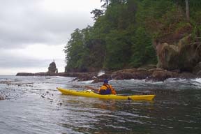 and clear you won’t want to proceed, but in calm conditions paddle west along the rugged coast and the jutting headlands toward the very apex of western Washington, Cape Flattery. All along this stretch of coast the land rises in rocky cliffs from the waterline, and it is here that the secrets of this place will be revealed. Deep coves cut into the shore and there, tucked within the walled confines, can be found sea caves of spectacular nature. Some are vaulted, cavernous cathedrals while others are mere slots cut into the headlands.
This is the kind of paddling that brings back memories of childhood storybook adventures along the lines of Peter Pan. It is only revealed to those with enough imagination to pursue an elusive dream. The only time a paddler can approach these caves is when the Pacific Ocean wave machine has been temporarily turned off, and one of the best times to witness this is a calm fall day.
Time: day tripRound-trip mileage: 10 miles, day paddle
Rating: Advanced
Charts: NOAA Chart 18480
Boat rental: Best to rent boats in Seattle before heading to the Olympic Peninsula; stop by Northwest Outdoor Center (206-281-9694) on Lake Union at 2100 Westlake Avenue beforehand. (http://www.nwoc.com/rental/)
Good food: On the way back through Port Angeles, stop for dinner at Belle Italia (good seafood here, too), 117-B East First Street, 360-457-5442.
References: This trip is a secret and is not listed in the guidebooks.
Directions: From Seattle, drive north to Edmonds and take the ferry to Kingston. Drive Highway 104 through historic Port Gamble, across the Hood Canal Bridge to its junction with Highway 101, and follow Highway 101 to Port Angeles. From Port Angeles, drive Highway 112 through logging country to the town of Neah Bay and the launch point.
Blake Island
In the middle of the bustling metropolitan area of Seattle is a paddling destination that feels far away from the big city while offering a view of its bright lights when the sun sets. Blake Island offers an excellent overnight or day trip with several different approaches.
A four-mile crossing of Puget Sound awaits you with a launch from Alki Point, but shorter alternatives are available. By riding the Fauntleroy ferry from Lincoln Park to Southworth on the Kitsap Peninsula, you can shorten the crossing to Blake Island to a single mile of protected and slow-moving water. In calm conditions the longer crossing from Alki is the way to go, but watch out for shipping traffic and consider returning by way of the ferry if the weather kicks up.
Blake Island is unique in that it provides the paddler with both a civilized and wild face. On the east end is a small marina, campground, picnic shelters, and a complex called Tillicum Village, which includes a traditional Indian longhouse. During the weekends in the fall you can reserve a space in the longhouse, and you will be treated to a salmon dinner and traditional dance demonstration. Folks arriving by tour boat from the city will join you here, but the experience is quintessentially Seattle, and is well worth the loss of solitude.
On the other two points of the island, south and west, can be found more primitive camping sites if solitude and views away from Seattle are more to your liking. But if you simply can’t resist a salmon dinner, there is a network of trails around and over the island that will lead you to Tillicum Village.
Time: day trip or overnight
Mileage from Alki Point: 4 miles
Paddling distance around Blake Island: 5 miles
Rating: Beginner to Intermediate, depending on launch point
Charts: NOAA charts 18445 SC, 18448, or 18449
Boat rental: For paddling in the Seattle area, boat rental is best done at the Northwest Outdoor Center on Lake Union at 2100 Westlake Avenue; 206-281-9694. (http://www.nwoc.com/rental/)
Good food: Eating anything other than fish and chips in this salty town smacks of heresy, so check out the best of what Seattle has to offer - The Sunfish. Just back from Alki Beach, there is no better in town: lightly breaded fish fried to perfection. And don’t miss the salmon at Tillicum Village when on the island.
References: Kayaking Puget Sound, The San Juans and Gulf Islands, by Randel Washburne (Published by The Mountaineers).
Directions: From Interstate 5 north or southbound through Seattle, take Exit 163, cross the West Seattle Freeway bridge, and exit at Harbor Avenue Southwest. Follow the road north to Alki Avenue Southwest, and then to Alki Point. Several launch points are possible on the south side of Alki Point, and at the Fauntleroy ferry dock.
Barkley Sound, Vancouver Island, British Columbia
On the southwest coast of Vancouver Island, in western Canada, one of the finest paddling destinations you will come across awaits the hull of your boat, and it’s not too late to go, even in early fall. Within a strong bubble of good weather in September, the islands of Pacific Rim National Park - known as the Broken Group - will be stunning.
Although Barkley Sound faces southwest into the full fury of the Pacific Ocean, the Broken Group maintains a unique 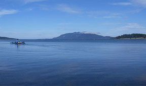 combination of exposed outer islands and relatively protected inner ones. Access to the 100 islands of the Broken Group is also varied. From the road’s end at Toquart Bay to the north, more experienced paddlers can approach the islands across Loudoun Channel, which is exposed to the Pacific. Novice paddlers, or those simply wishing for a taste of local history, can ride (along with their boats) aboard the MV Lady Rose or MV Francis Barkley to the old whaling station of Sechart, immediately north of the islands. This option allows for shorter and more protected access to the Broken Group.
However you approach the Broken Group, you are sure to be rewarded with adventure. A great central campsite is located on Willis Island, and from here you will be able to do day trips to all corners of the park. Fishing, whale watching, beachcombing, birding, snorkeling, and tide-pooling add to the paddling, making for a rich experience. In addition to recreation, you will find yourself surrounded by cultural history as well. These islands have been home to the Nuu-chah-nulth people for thousands of years, and more than 100 culturally significant sites are found within the island group.
Time: 4 Days or moreRound trip to Willis Island from Toquart Bay: about 11 miles
Rating: Beginner to Intermediate, depending on launch point and routes in the islands
Charts: Canadian Charts 3670 and 3671
Boat rental and freighter transport: Contact Lady Rose Marine Services at 250-723-8313; P.O. Box 188, Port Alberni, BC, Canada, V9Y 7M7. (http://www.ladyrosemarine.com/)
Good food: The Clam Bucket in Port Alberni serves up a serious pail of bivalve mollusks.
References: Kayak Routes of the Pacific Northwest Coast, edited by Peter McGee (The Mountaineers and Greystone Books).
Directions: From Seattle, drive I-5 north across the border into Canada. Follow signs to the Tsawwassen Ferry. Take the two-hour ferry ride to Nanaimo, drive Highway 19 north to the Qualicum Beach/Port Alberni turnoff, and follow Highway 4 to Port Alberni. For the Toquart Bay launch site, continue along Highway 4 to the west for 55 miles to a gravel road on the left. Follow this logging road to the camping area at Toquart Bay.
