
learn
Road Cycling At Big Bear Lake, CA
By Mike Boisvert.
Start your engine at the Los Angeles ocean and in less than 100 miles you'll be tucked into the San Bernardino Mountains at 7,000 feet [a trip that would have taken two days by horse-drawn carriage in the gold-rush era].
Whether you are a vacationer, visitor, second homeowner or full time resident, Big Bear Valley is one of the finest cycling areas in all of California!
Riding at 7,000 – 8,500’ is just like training with the pro’s and with their beautiful outdoor atmosphere, 330 days of sunshine and their clear, cool weather, it just doesn’t get any better than Big Bear!
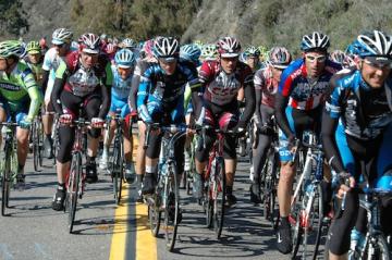
Big Bear Lake road cycling burst onto the international scene in 2010 as a Stage Finish for Stage #6 of the Amgen Tour of California. This 135 miles, 13,000 foot stage was complimented by international cycling announcer Phil Liggett in his comment that “we have just been treated to one of the best cycling stages we’ve seen in America, ever!” and was also the subject of an extensive article in Velo News comparing Stage #6 to the most difficult stages in the Tour de France.
Big Bear Lake is emerging as a biking meccca with a road cycling scene galvinized by Big Bear Cycling Association [has guided and organized rides Saturday, Tuesday, Wednesday, Thursday during the spring/summer/fall riding season]. The Big Bear Cycling Association hosts weekly community rides aimed at including absolute beginners in a short to medium distance ride on city streets. Meets every Saturday at 9am at Copper Q in the Village. They bring a mechanic in case you haven’t seen yours lately!
Bike rentals are available from Bear Valley Bikes.
 Best Road Cycling Routes
They are blessed to have bike route signage on city streets. By following these signs, you can travel safely from one end of the valley to the other mostly on back roads, with only short connections on the busy highways. Explore each neighborhood on your bike and you’ll get a great fitness-building workout and a scenic tour of Big Bear’s most pleasant places.
Distances that are commonplace in a car can be challenging on bike, and you’ll see things you never noticed before as you whizzed by behind rolled-up windows. But on a bike, you’ll have a new appreciation for scenery, serenity, and good friends. Pick something within your comfort zone at first, then go a little farther next time. Plan trips by what sounds fun, or maybe even a bit ridiculous, then con or cajole some friends into going with you, and go for it!
Cycling is part of the casual outdoor lifestyle found in the San Bernardino Mountains. Road enthusiasts can ride from the simple City Bike Routes to the climbing challenge of Onyx Summit.
Lake Circle ~ 18 miles
Generally Flat – Trail can begin from anywhere in the city and goes around the scenic shores of Big Bear Lake and through surrounding neighborhoods in Big Bear Lake. Basic route will take you on city streets and state highways. From City Hall, head west on Highway 18 to Big Bear Dam. Turn right on Highway 38 at Dam and go east across North Shore Drive through town of Fawnskin, past Big Bear Discovery Center to Stanfield Cutoff. Right on Stanfield Cutoff to Big Bear Blvd., Right on Big Bear Blvd and a variety of routes can be taken to get through city and back toward City Hall.
North Shore ~ 38 miles
Rolling Hills and Fast Flats – Trail can begin almost anywhere in Valley and get to North Shore Drive. Head west to Big Bear Dam, turnaround and head east all the across to the top of Cushenbury Grade. Turnaround at Cushenbury Grade and turn left on Baldwin Lake Road and follow Baldwin Lake Road around until it becomes Shay Meadow Rd and wind your way back through Big Bear City and Big Bear Lake on signed bike routes.
Onyx Summit ~ 16 miles
Climbing from 6750 to 8500 feet – the best true climb within Big Bear Valley. This is State Route 38 as it climbs out of Big Bear Valley at the far east end. This ride is usually added onto to one of the previous rides for more high altitude training!
Get a high-resolution print version of the areas cycling routes: Big Bear Lake Bike Map front (808K) and back (204K) in PDF format. (Requires the free Adobe Acrobat Reader)
© 2012 Gay Outdoors ; All Rights Reserved.
