Trip report
Temescal Canyon to Skull Rock
Hiking/Walk DATE: 01/17/2015 - 01/17/2015
Trip/Event Location: Pacific Palisades, CA
US
Trip Leader(s):
Max # People: 30
Trip Guiding / Event Fee: No, I will not be asking participants for money
Difficulty Level: Moderate
Date: January 17, 2015
Time: 9:30 am
Near: Pacific Palisades, CA 90272
Distance: 6.25 miles round trip
Difficulty: Moderate
Elevation: 1000 feet
Hike Time: 4 1/2 hours
Trail Type: Trail
Directions: From Santa Monica, drive north on Pacific Coast Highway 1 to Temescal Canyon Road and turn right. Drive approximately 1.1 miles until you reach Sunset Blvd. There is plenty of parking on the street. Enter Temescal Gateway Park and stay on the left. We will meet at the tables near the restrooms covered in stone.
What to Bring: Good hiking boots/shoes. A hiking/trekking pole may be useful for the occasional step ascent/descent on the trail, but not necessary. Pack a lunch, snacks and bring plenty of water. Bring a hat/cap and sunscreen.
Carpooling: Contact other members to carpool; share the conversation and travel expenses.
Hike Leader: Menard Jaramillo
Rain Cancels
Trip Report/Photos
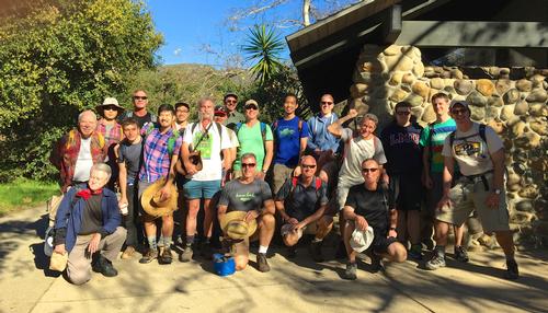
Our hike started at 9:50 and we had 20 members from the Gay Outdoors and the Great Outdoors. It was a perfect day for hiking in Southern California. We had mid-70's weather with clear beautiful blue skies. The recent rains had greened up the hills and was very beautiful. We had views of the various island in the Pacific and could see snowcapped Mt Baldy to the east, as well as the mountains in Palm Springs. After the hike we had a social at a coffeehouse. A nice day all in all.
- The Trip Has No Photos -
|
|
||