Trip report
North and South Hancock Hike
Hiking/Walk DATE: 03/21/2015 - 03/21/2015
Trip/Event Location: Lincoln, NH
US
Trip Leader(s): Gandalf , JDNnh
Max # People: 15
Trip Guiding / Event Fee: No, I will not be asking participants for money
Difficulty Level: Moderate to Strenuous
We will climb two 4,000 footers off the Kancamagus Highway! The majority of the hike will be in and on the same trail [3.5 miles] before we get to the Hancock Loop Trail. Hopefully the North Folk
...According to Google Maps the trailhead is about 140 miles from Boston and it should take about 2 hours 30 minutes to drive there.
The Hancock Overlook parking area is on New Hampshire Route 112 [Kancamagus Highway] about 10.5 miles east of Interstate 93, exit 32. It's on the south side of the road, immediately east of the hairpin right turn where traffic is supposed to slow down to 20 miles per hour, and a sign warns of parking 600 feet. We will be driving a blue Toyota FJ Cruiser.
Carpooling is encouraged so you are responsible for coordinating your own rides. Use the comments section below to communicate with other members who may also be looking to share a ride. If you do share a ride be sure to share the expenses ~ suggested donations per person are $20 from Boston, MA; $15 from Salem/Nashua, NH; and $10 from Concord, NH.
Trip Report/Photos
Total Distance: 9.8 mi.
Total Time: 7 hours 30 minutes
Total Elevation: 2700 ft gained
The weather forecast from the National Weather Service was predicting mostly cloudy skies with a high of around 30ºF above 4000 ft with not much wind. We were prepared for no views from the top. The forecast was completely wrong.
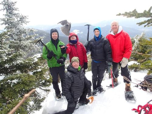
We made rather quick work of the first 3.6 miles over relatively flat ground to the junction of the North and South links of the of the Hancock Loop Trail. Three of us started on MicroSpikes while the other two wore snowshoes. The trail was packed powder with a soft surface, solid enough early for bare boots and microspikes up to the Hancock Loop Trail, but vulnerable to postholing as the sun came out later in the morning. From there, the Hancock Loop Trail was badly chopped up. All us used snowshoes at the start of the North and South links of the Hancock Toop Trail knowing we would need the televators for the ascent and the shoes in general for the drifting on the ridge. We choose to ascend to Mt. Hancock first, which is the way Jon & I had previously hiked this loop in winter.
The hike up to Mt. Hancock was incredibly steep. The televators aided us and made it bearable, but it was one hell of a workout. The sun was out and it felt really warm at the outlook/blow down just below the summit so we took some photos and enjoyed the warm sun. We made our way to the summit.
Upon arriving on the summit there was no wind, temperatures were probably in the mid 20s, it was sunny and there were views! We went to the summit outlook for lunch and took some great photos. The clouds were moving around the summits from an approaching cold front. After lunch we started along the ridge.
The trail along the ridge went from well packed to some drifted snow. The conditions were all over the place due to the wind that whips through this area. We ran into a couple, one of whom plummeted into a trailside spruce trap right before our eyes, shoulder-deep. No snowshoes. Just before South Hancock we got some great views of the Arrow Slide and the Franconia Ridge.
At South Hancock we carefully made our way down to the outlook to see the views of Mt. Chocorua and the some of the other mountains of the eastern portion of the Sandwich Range.
We then started our descent. With two long butt slides we would make it down the mountain in less than 15 minutes.
We then kicked into zombie mode and hiked out the 3.6 miles back to the hairpin curve parking lot.
Everyone came back over the house for appetizers/beverages beside the fireplace, grilled steak dinner prepared by Jon and a relaxing evening watching Ultimate Survival Alaska.
Jon and Mike
- The Trip Has No Photos -
What Members Are Saying About This Trip/Event
- The Gray Jays welcomed us to the mountain and we fed them well. A fantastic "spring" hike and heart-pounding ascent. Thanks guys for a memorable day! - JDNnh
- Hi Mike & Jon: Had a great time! Perfect conditions for the BUTT slide! Great dinner & evening- thanks for the hike! The Montreal Seasoning on the steaks was delicious.... - Bobcat
|
|
||