

Member Trip report
Mt. Tecumseh
03/25/2014
Trip Report/Photos from Gandalf
Yet another cold morning in late March, -2 F but it warmed up into the 20s in the valleys. Still, this snowshoe trek up the packed-powder track of the Mt. Tecumseh Trail was a winter hike. Things were quiet at the Waterville Valley Ski Area, and even at 10ish I was able to park directly across from the trailhead.
I started with bright sun in the hardwoods on the lower part of the trail. There were beautiful skies at the ski trail viewpoint, 1.2 mi. up from the trailhead with the classic view of the Tripyramids.
Then began the "endless mile" above the ski trail viewpoint that starts out as a wide chute where it has been carved out by skiers and snowboarders, who drop in at an unofficial access path above. Above the access route (ca. 3000 ft.) the trail narrows. The trail splits at the base of Tecumseh's steep summit cone: Mt. Tecumseh Trail to the R, or Sosman Trail to the L. Most hikers use the less steep and more scenic Sosman option.
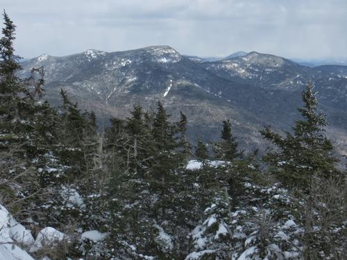
Not far up the Sosman Trail there are some neat views to the W, enhanced by deep snow cover. The Kinsmans rise above the crest of West Tecumseh and Mt. Moosilauke is seen beyond the talus patches on the SW ridge of West Tecumseh.
The summit viewpoint has been "enhanced". It certainly makes Tecumseh a more attractive destination, but one would hope that whoever is doing this would obtain permission from the Forest Service before undertaking any view clearing. The views spread of the western Sandwich Range, Mt. Passaconaway peeking over to the R of South Tripyramid and Mt. Whiteface rising above Snows Mountain.
I followed a partly broken snowshoe track 0.1 mi. down the N side of Mt. Tecumseh Trail to a northerly outlook. The views were pretty fuzzy in that direction, so no photos. Respectable snow depth here!
I made a short bushwhack to a southern viewpoint, also "enhanced," atop a steep dropoff. The neatest part of this vista is the ledgy spur ridge coming off the summit of "SW Green," with Hogback and Fisher Mountains behind. It's a wild area out there. There were views of Sandwich Dome beyond the ski slopes, and I Waterville Valley - "the Town at the End of the Road" - with Mt. Whiteface beyond.
I enjoyed the late afternoon light that descended the Mt. Tecumseh Trail. The upper crossing of Tecumseh was completely buried. Where, oh where is spring?
- The Trip Has No Photos -
