

HIKES & EVENTS
Echo Mountain via the Sam Merrill Trail
Hiking/Walk
DATE: Nov 12, 2016
END DATE: Nov 12, 2016
Hike/Event Location: Altadena CA
Trip Leader(s)
Meeting Time: 9:30 AM
Max # People: 30
Hike Guiding / Event Fee: No, I will not be asking participants for money
Hike Difficulty Level:
Easy to Moderate
(Do you qualify to attend with this hike difficulty rating? Click Here.)
Sign Up To This Trip/Event
You must be a least a guest member to participate. Comments such as "+1" or "bringing a friend" are NOT permitted. All participants must sign-up for the event individually.
Select your mode of transportation, make any comments and then click on button.
You are not logged in.
Please, Log In
Summary

Distance: 6.5 miles round trip
Difficulty: Moderate
Elevation Gain: 1400 feet
Hike Time: 4 hours
Hike Type: Out and Back
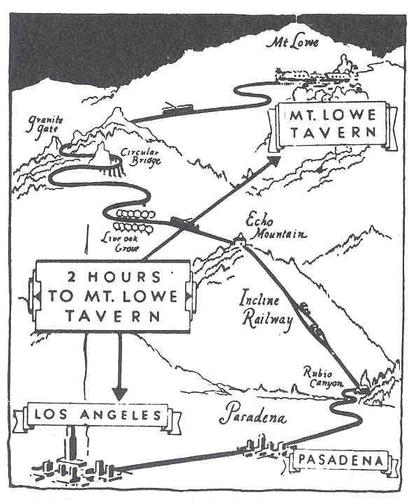
Summary: Professor Thaddeus Lowe, Civil War balloonist, had a dream to build a railway into—and a resort atop of the San Gabriel Mountains. In the 1890’s, the dream became a reality. During its height of its popularity, millions took the “Railway to the Clouds” to fine hotels and spectacular views of Los Angeles. It was considered Southern California's must-visit attraction. The complex at Echo Mountain (3207'), known as "The White City," contained elegant Echo Mountain House hotel, a chalet, an observatory, a small zoo and a magnificent searchlight purchased from the Chicago World’s Fair. When the searchlight swept the mountaintop, it was visible from all over LA. It was coined “The White City”, because it was painted stark white and visible from the LA basin below.
From Pasadena, visitors rode a trolley up Rubio Canyon. After taking refreshments, they boarded the “airships” of the great cable incline, which carried them 3,000 feet (gaining 1300 feet) straight up to the Echo Mountain Resort. The trip to Echo Mountain was via 18 trestles and 127 hairpin turns. From Echo Mountain, visitors could also board a trolley and ride a few miles to Mt. Lowe Tavern at the end of the line.
Wind fueled fires, windstorms and floods destroyed the complex over the years and was abandoned in the 1930’s. It has all since vanished, but this fascinating hike takes you to the ruins of this official historic landmark.
Directions To Trailhead Parking Lot
Trailhead: From the I-210 Foothill Freeway in Pasadena, exit at Lake Avenue. Drive north for 3.4 miles to the end of Lake Avenue (where it intersects with the terminus of Loma Alta Drive running east and west). Park along the street. Carpooling: Contact other members to carpool; share the conversation and travel expenses. We will meet at the stone-pillared gate of the former Cobb Estate.
What to Bring: Good hiking boots/shoes, snacks, plenty of water, hat/cap and sunscreen. For those interested, we will have lunch at a local restaurant following the hike. If you decide not to join us for lunch, bring snacks/food that you can eat during our breaks. Restaurant: Bonnie B’s Smokin’ BBQ Heaven, 1280 N Lake Ave, Pasadena 91104. http://www.bonniebssmokin.com/
Rain Cancels.
Menard is leading this hike for both the Gay Outdoors and the Great Outdoors members. Note: women may be participating.
Trip Leader
members signed up for this event

 Invite To Be Your Buddy
 Send Email
- Online Status: OFFLINE
- Last Login: 12/19/2020 12:12 AM
- Member Since: 02/08/2016
- I Need A Ride
- Comment: This hike is taking place on my birthday. I was wondering, is it a nude hike?

- Online Status: OFFLINE
- Last Login: 03/07/2021 09:32 AM
- Member Since: 01/23/2011
- Driving My Own Car
(Willing to give guys a ride)
- Comment: Sounds like fun
 |
 |
